GPX to video: turn your GPS track into a 3D MP4
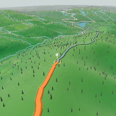
Convert GPX to video in the browser: upload a GPX, FIT, or TCX track and Flyover draws it over 3D terrain, so you can export the result as an MP4. Choose the camera and terrain, add your photos to the timeline, and compose a landscape video or a vertical version for Reels. The GPX animation is built from the track alone; no video footage is needed.
What your GPX file can show
GPS coordinates define the route across the 3D map. Add route progress and an elevation panel to make the journey easier to follow. FIT and TCX files may also contain heart rate, power, or cadence; those panels use sensor values only when the activity includes them.
A finished scene sequence from one route
For activity recaps and route previews, Auto Story uses route shape, climbs, descents, and supported activity moments to produce an ordered sequence you can review scene by scene and edit in the same Studio.
Upload a GPX, FIT, or TCX activity with a usable GPS track.
GPS coordinates define the route across the 3D map. Add route progress and an elevation panel to make the journey easier to follow. FIT and TCX files may also contain heart rate, power, or cadence; those panels use sensor values only when the activity includes them.
Set 16:9, 9:16, 1:1, or 4:5 at 30 or 60 fps. Export the finished route as an MP4 in 720p, 1080p, or 1440p, so the preview is composed for the frame you will use.

Add photos to your animated route
Place a summit photo, café stop, trailhead, or finish image at its corresponding route stop. During the flyover, the photograph appears with the surrounding terrain still in view, connecting the moment to the place where it happened.
GPX to MP4 for Reels and landscape video
Set 16:9, 9:16, 1:1, or 4:5 at 30 or 60 fps. Export the finished route as an MP4 in 720p, 1080p, or 1440p, so the preview is composed for the frame you will use.
Open Flyover StudioWhat the file becomes in the editor
- Upload GPX, FIT, and TCX files with usable GPS coordinates.
- Add photo stops to create a route timeline around real places.
- Keyframe camera, visual style, intensity, weather, time, season, and panels.
- Use route and elevation panels; show sensor metrics when the file provides them.
- Export a new MP4 in 720p, 1080p, or 1440p.
From GPX file to MP4 video
- 1Upload a GPX, FIT, or TCX activity with a usable GPS track.
- 2Place photos and edit the camera, appearance keyframes, and route panels.
- 3Choose the output aspect ratio, preview the composition, and export an MP4.
FAQ
Can I convert a GPX file to MP4?
Yes. Upload a GPX file with usable GPS coordinates, edit the route animation, and export a new MP4.
Is GPX to video free?
You can export for free within limits. The free export is 720p with stylized terrain and a TrainCraft watermark; 1080p, 1440p, satellite imagery or an export without the watermark need a paid export.
Will an indoor activity file work?
Only if the file includes a usable GPS track. Indoor sensor data without route coordinates cannot draw a route animation.
What is the difference between GPX, FIT, and TCX?
All can provide a route. FIT and TCX may include heart rate, power, or cadence; panels use those values only when the file supplies them.
Is this an overlay for action-camera footage?
No. Flyover creates a new terrain and map-based route video from uploaded GPS data.
Which video formats can I export?
Export MP4 in 720p, 1080p, or 1440p, using 16:9, 9:16, 1:1, or 4:5 at 30 or 60 fps.